

The Sefton Park to Otterspool route is considered the best riverside walk in Liverpool because it connects 235 acres of Grade I listed historic parkland directly to the iconic tidal shoreline of the River Mersey via continuous green corridors.
- How Do You Navigate the Route from Sefton Park to Otterspool Promenade?
- What Historical Landmarks Can Walkers Discover Along the Sefton Park to Otterspool Route?
- What Wildlife and Natural Ecosystems Are Present Along the Mersey Estuary Walk?
- What Are the Best Practical Tips for Planning Your Walk from Sefton Park to Otterspool?
- Frequently Asked Questions
- How long does it take to walk from Sefton Park to Otterspool?
- Is the Sefton Park to Otterspool walking route wheelchair and pram accessible?
- Are dogs allowed on the walk between Sefton Park and Otterspool?
- Where is the best place to park when doing the Sefton Park to Otterspool walk?
- Are there public food and toilet facilities along the walking route?
This walking route offers an exceptional combination of urban nature, architectural heritage, and open waterfront landscape within South Liverpool. The path transitions from cultivated Victorian parkland through residential green belts to an elevated promenade along the Mersey estuary. Hikers and casual walkers encounter historic monuments, diverse botanical collections, and panoramic marine views within a single four-mile trajectory. The geographical accessibility via public transport links further reinforces its status as a premier urban walking experience in North West England.
Historically, Sefton Park opened in 1872 as a public health initiative to provide clean outdoor space for Liverpool’s expanding industrial population. Designed by French landscape architect Édouard André and Liverpool architect Lewis Hornblower, the park features a circular perimeter road, naturalistic water bodies, and expansive meadows. Otterspool Promenade was constructed in the 1930s using material excavated during the build of the Queensway Mersey Tunnel. The promenade project stabilized the coastal mudflats and established a structured barrier against the strong tidal flows of the Mersey estuary.
The structure of the walk relies on a natural gradient sloping southward toward the river bank. Walkers start at the central Palm House in Sefton Park, follow the outlet stream of the Park Lake, and navigate through the leafy residential streets of uk/local/aigburth/">Aigburth. The route connects with Otterspool Park before terminating at the exposed promenade sea wall. Key components include the Palm House, the Shaftesbury Memorial Fountain, the historic Otterspool landfill reclamation zone, and the expansive mudflat ecosystem of the Mersey estuary.
The process of navigating this route involves moving across three distinct ecological zones. The parkland zone contains over 1,000 trees, freshwater streams, and structured gardens. The intermediate urban zone consists of Victorian residential architecture along Aigburth Vale. The coastal zone features salt marsh vegetation, intertidal mudflats, and marine tidal movements that change the landscape twice daily. Strong river currents and tidal ranges of up to 10 meters characterize the Otterspool portion of the path.
Real-world usage of the path ranges from local daily exercise to regional tourist visits. Cyclists, runners, and dog walkers use the wide asphalt surface of Otterspool Promenade due to its complete separation from vehicular traffic. Outdoor enthusiasts often extend the route northward toward the Royal Albert Dock or southward toward Garston Coastal Reserve. The path serves as an vital green respiratory system for dense residential districts including Aigburth, Mossley Hill, and Toxteth.
Data from local authority surveys shows that Sefton Park and Otterspool Promenade receive millions of visits annually. Sefton Park spans 235 acres, while Otterspool Promenade covers roughly three miles of continuous paved waterfront. The River Mersey estuary adjacent to the promenade is designated as a Site of Special Scientific Interest due to its international importance for wintering waterbirds. Over 20,000 wildfowl and waders utilize the intertidal mudflats along the Mersey during peak winter migration periods.
The long-term impact of maintaining this walking corridor centers on urban climate mitigation and public health promotion. Continuous green spaces reduce urban heat island effects and absorb surface runoff from heavy rainfall events. The promenade sea wall acts as essential flood defense infrastructure protecting South Liverpool from coastal erosion. Local authorities continuously invest in biodiversity restoration along the coastal path to support native bird populations and estuarine habitat health.
How Do You Navigate the Route from Sefton Park to Otterspool Promenade?
Navigating the route from Sefton Park to Otterspool Promenade involves walking south past the park boating lake, crossing Aigburth Road into Aigburth Vale, following the path through Otterspool Park, and emerging onto the paved waterfront promenade.
The directional flow begins at the Palm House inside Sefton Park, heading southwest toward the southern perimeter gates near Aigburth Road. Upon exiting the park, the route follows Aigburth Vale, a short road section that leads directly into the tree-lined entryway of Otterspool Park. Walkers follow the main paved path through Otterspool Park, passing beneath the Merseyrail railway bridge. The path terminates at the open river wall of Otterspool Promenade, providing immediate access to the waterfront walkway.
The historical development of this connection dates back to the early 20th century when South Liverpool urban planners sought to link interior green spaces with coastal land. Aigburth Vale served as a natural valley carrying Otter’s Pool stream from the park to the river. The stream was culverted underground during municipal development in the 1920s and 1930s, leaving a clear surface alignment for pedestrians. The installation of the railway line in the late 19th century required a pedestrian underpass, which remains a key navigation landmark today.
The key components of this navigation path include clear signage, wide pedestrian pavements, and minimal roadway crossings. The Sefton Park section covers smooth gravel and asphalt footpaths surrounding the lake. The Aigburth Vale transition section features controlled pedestrian crossings over main arterial roads. Otterspool Park contains undulating asphalt paths beneath a dense canopy of mature woodland. The final promenade section consists of a flat, extra-wide concrete sea wall walkway designed for multi-directional pedestrian traffic.
The navigation process requires walkers to manage terrain transitions over a total distance of approximately 3.5 miles. Elevation decreases steadily from Sefton Park down toward sea level at Otterspool. Walkers cross two main roads, including Aigburth Road, where push-button signalized crossings ensure pedestrian safety. Navigation remains straight, requiring minimal map consultation due to prominent visual landmarks such as the Palm House at the start and the open river at the finish.
Specific examples of navigation landmarks include the historic Bandstand in Sefton Park, the Aigburth Vale bus terminus, and the railway bridge portal at Otterspool Park. Walkers who want to explore local dining or shopping during their journey often take short detours into the surrounding neighborhood to experience what are the best things to do in Aigburth Liverpool. Another prominent landmark near the route end is the Otterspool Adventure Centre, situated near the northern section of the riverfront.
Statistical measurements indicate the entire walk takes between 60 to 90 minutes to complete at a moderate pace of 3 miles per hour. The total distance from the northern edge of Sefton Park to the southern point of Otterspool Promenade measures 3.8 miles. Elevation change along the entire route is minor, dropping roughly 35 meters from the high point of Sefton Park down to the coastal high water mark. Pavement width along Otterspool Promenade measures 8 meters, accommodating large numbers of users simultaneously.
Effective navigation along this green link improves pedestrian safety by isolating walkers from major traffic corridors. Integrating internal parkland with external coastal infrastructure encourages sustainable travel across South Liverpool. The route forms a key segment of the longer Mersey Way national trail, demonstrating how local navigation paths integrate into regional walking networks. Urban planning initiatives continue to upgrade directional signage to make the route fully accessible to all mobility levels.
What Historical Landmarks Can Walkers Discover Along the Sefton Park to Otterspool Route?
Walkers discover multiple Grade II and Grade I listed landmarks along the route, including the Palm House, the Shaftesbury Memorial Fountain, the Peter Pan statue, and the historical site of the 1984 International Garden Festival.

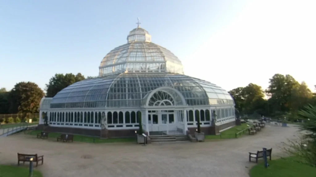
These monuments showcase Victorian architectural engineering, public art traditions, and late-20th-century landscape urbanism. The Palm House stands as an iconic glass and iron conservatory featuring rare botanical specimens. The Shaftesbury Memorial Fountain features a replica of Eros, matching the famous London monument. Further along the coastal path, the reclaimed site of the International Garden Festival marks a major milestone in Liverpool’s post-industrial regeneration history.
The historical context of these landmarks reflects Liverpool’s prosperity as a global port city during the 19th and 20th centuries. Philanthropists and civic leaders funded Sefton Park’s structures to demonstrate municipal prestige and foster public cultural education. Henry Yates Thompson donated £10,000 in 1896 to construct the Palm House, which was manufactured by ironmaster Mackenzie & Moncur. The International Garden Festival of 1984 was initiated by the Michael Heseltine led initiative to regenerate derelict dockland and landfill space following economic decline.
Structural elements of these landmarks represent distinct construction eras and engineering methodologies. The Palm House utilizes a three-tiered dome constructed from glass panes supported by a cast-iron frame, housing eight bronze statues by sculptor Émile François Chatrousse. The Shaftesbury Memorial Fountain is crafted from granite and bronze, designed by Alfred Gilbert. The International Garden Festival site incorporates oriental garden architecture, Japanese pagodas, and artificial hills constructed over stabilized river sludge and domestic waste deposits.
The preservation process of these historical landmarks requires ongoing structural maintenance and heritage funding. The Palm House underwent a massive restoration effort during the late 1990s after falling into severe disrepair, re-opening officially to the public in 2001. The International Garden Festival site went through extended redevelopment phases, resulting in the reopening of public access gardens in 2012. Environmental monitoring systems maintain structural safety over the reclaimed landfill areas along the Otterspool boundary.
Examples of specific historical features include the statue of Peter Pan, sculpted by Sir George Frampton, installed in Sefton Park in 1928. Walkers also encounter the Fairy Glen, a man-made naturalistic sandstone ravine featuring cascading waterfalls and historic stone bridges. Along Otterspool Promenade, remnants of old river defense structures and historical tide markers stand visible near the original site of the Otterspool Pool stream discharge point.
Data records show the Sefton Park Palm House houses over 200 species of exotic plants, including several rare palm species dating back over a century. Sefton Park itself holds Grade I status on the National Heritage List for England, putting it in the highest category of historic importance. The 1984 International Garden Festival attracted over 3.3 million visitors during its six-month operational period, utilizing 125 acres of reclaimed land adjacent to Otterspool Promenade.
Preserving these historical landmarks maintains Liverpool’s cultural identity and boosts tourism along the South Liverpool corridor. Integrating historic monuments within public recreation routes enhances historical literacy among visitors and residents. These preserved structures provide physical evidence of the city’s transition from an industrial shipping hub to a center for green urban regeneration. Continued protection guarantees that future generations retain access to architectural and landscape heritage.
What Wildlife and Natural Ecosystems Are Present Along the Mersey Estuary Walk?
The Mersey Estuary walk hosts diverse natural ecosystems, including intertidal mudflats, salt marshes, mature broadleaf woodlands, and freshwater lake habitats supporting thousands of migrating bird species and coastal marine life.
These habitats form a critical ecological corridor running through South Liverpool, linking interior freshwater biology with estuarine ecosystems. Visitors along the coastal promenade observe shorebirds feeding on small invertebrates during low tide cycles. Interior park areas feature grey squirrels, waterfowl, and bats within mature tree canopies. The interface between terrestrial vegetation and tidal saltwater creates unique conditions for salt-tolerant plants and dynamic aquatic food chains.
The ecological background of the Mersey Estuary involves decades of environmental recovery. During the 19th and mid-20th centuries, heavy industrial discharge severely degraded the water quality and marine life of the River Mersey. Large-scale cleanup initiatives managed by the Mersey Basin Campaign starting in 1985 dramatically reduced pollution levels. The restoration of dissolved oxygen in the water allowed migratory fish to return and enabled intertidal organisms to recolonize the mudflats along Otterspool.
The ecosystem structure relies on the powerful tidal regime of the River Mersey, which experiences one of the largest tidal ranges in the United Kingdom. Intertidal mudflats consist of fine sediment rich in organic material, providing feeding grounds for burrowing invertebrates such as lugworms and Baltic tellins. The terrestrial border of Otterspool Promenade features managed grassland, gorse scrub, and native broadleaf trees like oak, sycamore, and ash. Sefton Park adds controlled freshwater habitats via its seven-acre boating lake and connecting streams.
Ecological processes along the route depend heavily on seasonal and diurnal cycles. Twice each day, the tide recedes to expose hundreds of hectares of mudflats, triggering mass feeding activity among resident and migratory birds. During winter months, the estuary serves as an essential stopover on the East Atlantic Flyway migration path. In interior parklands, seasonal vegetation cycles support insect populations, which in turn feed nocturnal bat species like the common pipistrelle.
Specific examples of bird species observed along Otterspool Promenade include redshanks, dunlins, Eurasian curlews, and grey herons. The freshwater lake at Sefton Park supports resident populations of mute swans, mallards, tufted ducks, and invasive ring-necked parakeets. Marine life inside the Mersey estuary now includes returning populations of Atlantic salmon, sea trout, grey seals, and harbor porpoises frequently sighted off the Otterspool sea wall.
Scientific monitoring confirms the Mersey Estuary holds European protected status as a Special Protection Area and a Ramsar site. The intertidal area regularly supports over 100,000 wintering waterfowl across the broader estuary system. Water quality testing by the Environment Agency rates the current Mersey Estuary biological status at its highest levels in over 150 years. Micro-invertebrate density within the mudflats reaches up to 50,000 organisms per square meter in peak feeding areas.
Protecting these coastal ecosystems ensures long-term environmental resilience for the city of Liverpool. Intertidal mudflats act as natural wave attenuation zones, dissipating tidal energy and reducing storm surge impacts on riverbanks. High biodiversity supports ecological stability and provides urban populations with access to wild nature. Sustained environmental management along the Otterspool boundary remains vital to prevent plastic pollution and habitat fragmentation from impacting estuarine marine life.
What Are the Best Practical Tips for Planning Your Walk from Sefton Park to Otterspool?
Planning the best walk from Sefton Park to Otterspool requires checking local tide times, wearing weather-appropriate footwear, utilizing public transport options, and choosing optimal times to avoid peak weekend crowds.
A successful walk depends on understanding the linear format of the route and preparing for coastal weather shifts along the river. While Sefton Park offers sheltered tree canopy cover, Otterspool Promenade lies exposed to wind off the Mersey estuary. Starting the walk in the morning allows visitors to explore park attractions before finishing at the riverfront. Checking public transport schedules ensures easy return transit from the end of the promenade back to central Liverpool.
The operational background of managing urban walking routes involves coordinated efforts between Liverpool City Council and public transport operators. Transport for Merseyside maintains integrated rail and bus services connecting South Liverpool with the city centre. Local council parks teams maintain footpaths, lighting, and refuse infrastructure across both Sefton Park and Otterspool. Public accessibility guidelines direct path upgrades to ensure wheelchair and pram accessibility along the entire walk.
Key components of walk planning include footwear selection, route mapping, water supply, and transport selection. Footwear should feature cushioned soles suited for asphalt and concrete surfaces, as over 80 percent of the path is paved. Public transport links include St Michaels and Aigburth railway stations on the Merseyrail Northern Line, both located within short walking distance of the route. Dedicated parking spaces exist at Sefton Park perimeter gates and at the central Otterspool Promenade car parks.
The execution process of planning begins with reviewing weather forecasts and Mersey estuary tide tables. Walking along Otterspool Promenade during high tide provides impressive marine views and crashing wave dynamics during windy conditions. Low tide reveals the extensive intertidal mudflats and bird feeding behavior. Visitors should allocate two to three hours total to allow time for rest breaks, photography, and visits to local cafes near Aigburth Road. Travelers seeking weekend trips often explore wider accommodation and travel details by reading an area guide for Aigburth Liverpool.
Practical examples of transit execution involve taking the Merseyrail train from Liverpool Central Station to St Michaels Station. Walkers walk ten minutes east along Aigburth Road to enter Sefton Park, complete the park circuit, and walk down to Otterspool. The return journey involves walking to Aigburth Station from the southern end of the promenade for a ten-minute train ride back to the city center. Bus routes 82 and 60 also run parallel to the route along Aigburth Road.
Data shows that Otterspool Promenade experiences its highest wind speeds during west and north-westerly weather systems coming from the Irish Sea. Average walk length measures 6,000 to 8,000 steps depending on side detours within Sefton Park. Both Sefton Park and Otterspool Promenade feature public toilet facilities, with Sefton Park offering facilities at the Palm House and main cafe, and Otterspool offering facilities near the adventure centre.
Thorough planning optimizes the health benefits and comfort of outdoor recreation in South Liverpool. Understanding route logistics prevents accidental trespassing on sensitive habitats and ensures personal safety near strong coastal tides. Accessible, well-planned walking routes encourage active transport alternatives, reducing local vehicle reliance and atmospheric carbon emissions. Adequate preparation ensures visitors experience the full ecological and architectural variety of Liverpool’s best riverside walk.
Frequently Asked Questions
How long does it take to walk from Sefton Park to Otterspool?
The walk takes approximately 60 to 90 minutes to complete at a steady, casual pace. The total distance spans roughly 3.5 to 4 miles depending on the specific paths taken inside Sefton Park. Adding visits to the Palm House or stopping at cafes along the way extends the overall time to two hours.
Is the Sefton Park to Otterspool walking route wheelchair and pram accessible?
Yes, the entire route from Sefton Park to Otterspool Promenade features paved, smooth surfaces with low gradients suitable for wheelchairs and prams. Dropped kerbs exist at all street crossings between the park and the promenade. Otterspool Promenade itself offers a broad, completely flat surface running parallel to the river.
Are dogs allowed on the walk between Sefton Park and Otterspool?
Dogs are welcome along the full length of the walk, including inside Sefton Park and along Otterspool Promenade. Dogs must remain under close control, especially near bird nesting areas along the Mersey intertidal mudflats and inside designated park zones. Many local cafes along Aigburth Road provide outdoor seating and water bowls for dogs.
Where is the best place to park when doing the Sefton Park to Otterspool walk?
Free parking is available along the perimeter road of Sefton Park (Aigburth Drive and Mossley Hill Drive) and in dedicated car parks at Otterspool Promenade. Because the walk is linear, visitors parking at one end can use the Merseyrail network between Aigburth or St Michaels stations to return to their vehicle easily.
Are there public food and toilet facilities along the walking route?
Public toilets and dining options are available at both ends of the route and along the mid-point. Sefton Park features public toilets at the Palm House and the Sefton Park Cafe. The mid-way point at Aigburth Road offers numerous independent cafes, while the Otterspool end features public amenities near the Otterspool Adventure Centre.